Investigating Mass Graves using Satellite Imagery
As part of SJAC’s most recent report on missing persons in formerly ISIS-controlled Syria, SJAC collaborated with the American Association for the Advancement of Science (AAAS) and the University of Dayton Human Rights Center in order to analyze satellite imagery of nine mass graves that have been exhumed in Northeast Syria. Satellite imagery can be an important tool in the investigation of graves, but it can be hard to determine when such imagery is appropriate and how much value it can add to an investigation. Today, SJAC is sharing some of the lessons learned through its use of satellite imagery, with the hope that other human rights investigators can decide whether satellite imagery may be an appropriate tool in their work.
Satellite imagery is not the best tool to establish the location of a grave in the absence of corroborating evidence.
When searching for graves, satellite analysts look for disturbances in the soil, such as holes or trenches. However, while these images can be the sign of a grave, they can also result from benign activities, including disruption from agriculture and irrigation systems. For example, in ISIS-controlled areas of Iraq and Syria, ISIS ran oil through complex trench networks to produce crudely refined fuel oil. AAAS shared with SJAC that, at first glance, such trenches can appear to be massive grave sites, even to investigators with years of experience in satellite imagery. Lack of local context makes searching for grave sites through satellite imagery alone difficult, and any findings should be considered tentative until further supporting evidence, such as witness testimonies, are discovered. Indeed, in post-conflict settings such as the former Yugoslavia and Sierra Leone, it was more traditional documentation like witness interviews that led to the initial identification of mass graves—not satellite imagery analysis. Ideally, investigators should use satellite imagery to search for graves in specific areas, only after corroborating documentation is collected and verified.
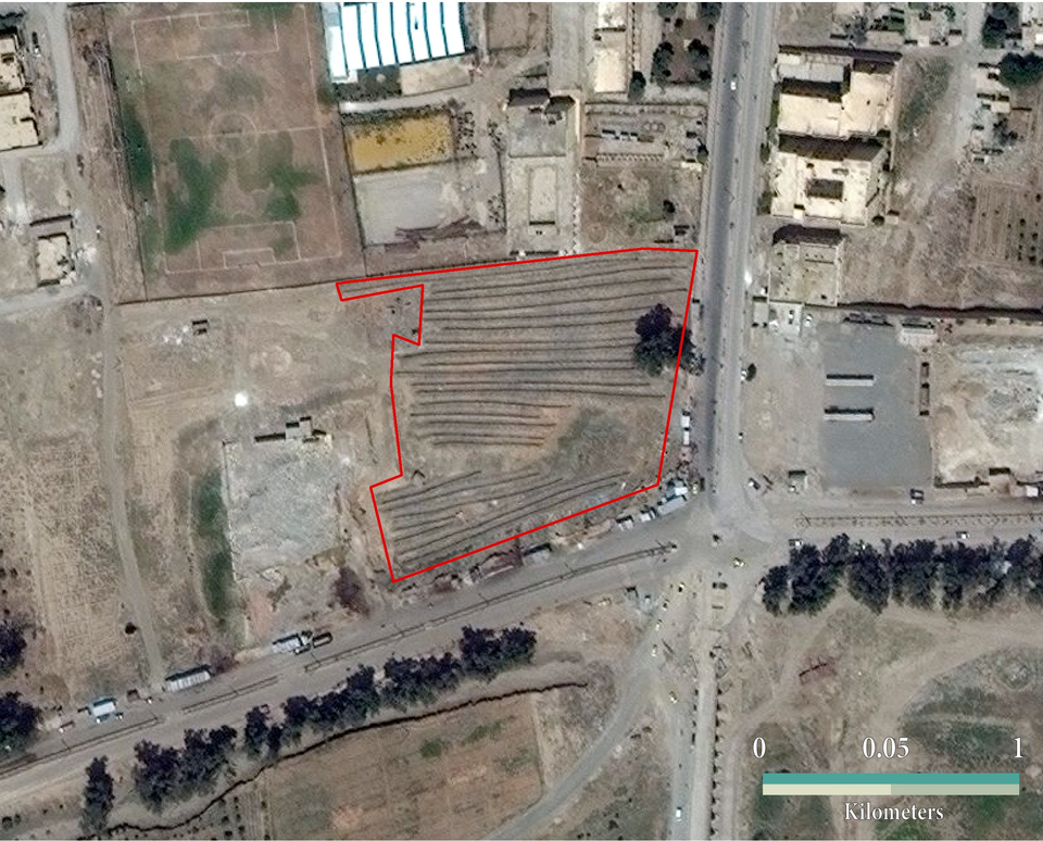
Satellite imagery can help establish precise timelines for the creation and use of individual graves.
In mass grave investigations, whether for the purposes of accountability or identification, it is integral to establish when a particular grave was created. A precise timeline can help investigators understand which victims may be in particular graves, by comparing their time of disappearance to the timeline of when the grave was completed. Investigators may also be able to connect a grave to a particular massacre or other crime with a known date of occurrence or to particular perpetrators who were active in the area when a grave was created.
AAAS/ Human Rights Center, University of DaytonIn the case of SJAC and AAAS’s investigations of graves in Northeast Syria, AAAS was able to precisely establish a timelines for several graves. In the below imagery, you can see Panorama Park in Raqqa in February 2017, with no evidence of graves visible. By May 2017 however, trenches began to appear. An image from February 2019 still shows the trenches, but they are beginning to fade, and no new trenches have appeared in the interim. Based on these images, AAAS concluded that this grave was in use from March 2017 – May 2017. SJAC can now utilize that information to narrow down which victims may be in that grave, and find local residents who were living in the area during that time and may have been witnesses to associated crimes.
Satellite imagery provides striking images for advocacy purposes.
Satellite imagery, particularly in the absence of exhumations, often provides the closest thing to an image of the crime itself. Raising awareness for crimes when there is no visual evidence can be difficult, but satellite imagery can help bridge this gap. A number of images discovered by AAAS’s investigation clearly show the appearance of massive trenches in the midst of Raqqa’s urban landscape, a stark symbol of the terror that ISIS wrought.
As is the case in almost all human rights investigations, when investigating mass graves, a single piece of evidence is rarely valuable on its own. Satellite imagery alone cannot prove the location of a grave, nor does its absence prove the grave does not exist. In some cases, imagery may not be available for the relevant dates, or perpetrators may have effectively covered up signs of the grave, by marring the ground through other, seemingly benign, methods. This is why investigations, whether for the purposes of criminal accountability or other justice processes, should rely on a large array of tools. In the case of investigations of killings and associated mass graves, satellite imagery can be valuable when used in tandem with witness interviews, and, when appropriate, forensic investigations and exhumations.
______________________________________________________
For more information or to provide feedback, please contact SJAC at [email protected] and follow us on Facebook and Twitter. Subscribe to SJAC’s newsletter for updates on our work